Inside The Disappearance Of Zealandia, Earth's Lost Continent
Hopefully, if given a quiz, we could all name Earth's seven continents: North America, South America, Europe and Asia (technically one whole landmass), Africa, Antarctica, and Australia, the latter of which is sometimes combined with the island chains to the north, Oceania. We also have enduring legends, tales, and speculation about other, ancient landmasses that drowned in the ocean, like Atlantis (described in various locations, but usually in the middle of the Atlantic Ocean) and Lemuria (connecting India to Africa and Oceania). Some evidence does exist for these places, usually connected to numerous flood myths loosely corresponding to the Younger Dryas (12,900 to 11,600 B.C.E.), a 1,300-year-long span of time that bridged the Pleistocene and Holocene geological eras and saw global temperatures and sea levels rise dramatically.
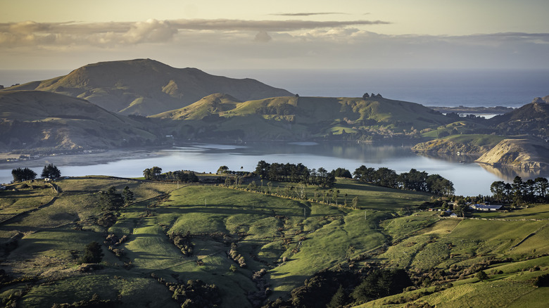
Some people may not know, however, that there is an actual, identified continent lost beneath the oceans' waves. The name of this continent is a dead giveaway regarding its location: Zealandia. A part of Zealandia sticks above the water and connects to the globe's most recently settled set of islands to the southeast of Australia: New Zealand, home to Hobbit holes and rugged, gorgeous scenery alike. Zealandia, which Popular Mechanics reported as fully mapped only as recently as September 2023, can tell us a lot about continental drift, i.e., how Earth's tectonic plates shift and move around over time. Zealandia was above the surface of waters 80 million years ago but plunged into the depths following its split from the supercontinent Gondwana.
The 'hidden continent' revealed
Even though Zealandia slid beneath the ocean surface, it didn't take an advanced human civilization with it. Earth's earliest known human progenitor species – Sahelanthropus tchadensis – didn't exist until at least 7 million years ago, and modern humans a scant 300,000 years ago, per the Smithsonian Natural Museum of History. So sorry, there's still no confirmed evidence of Atlantis or Lemuria. And yet, Zealandia's origins tell us a lot about Earth's past, and therefore its future.
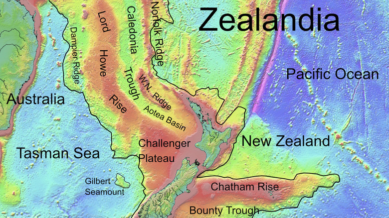
As maps on Business Insider show, Zealandia spanned 1.9 million square miles, or about half the size of modern-day Australia — itself an immense piece of land (as Aussies traveling between cities will attest). Zealandia stretches from New Caledonia east of Queensland and out towards Fiji and Tonga, south past New Zealand, and west into the Tasman Sea. Zealandia's size makes it a full-fledged continent rather than a microcontinent like the Madagascar and Mauritia microcontinents between Africa and India, and the Jan Mayen microcontinent northeast of Iceland across modern-day Spitsbergen, Norway, as the Geological Society of America explains.
And yet, despite its large, continental size, Zealandia only accounted for about 5% of Gondwana, one of Earth's previous supercontinents that existed from roughly 500 million to 180 million years ago, which as Earth.com says included Africa, Australia, Antarctica, India, and South America. But tectonic plates shift, continents fracture, and now 95% of Zealandia is underwater. Hence its nickname: Te Riu-a-Māui, the "hidden continent," per GNS Science.
[Featured image by Ulrich Lange, Bochum, Germany via Wikimedia Commons | Cropped and scaled | CC0 1.0 Deed]
Fractured by volcanic eruptions
The Geological Society of America says that Zealandia's borders trace a line connecting its continental slope to the bottom of the ocean at depths of about 1.5 to 2.5 miles deep. We've known about Zealandia for over a century, but it's only with advanced mapping techniques that we've been able to map the entire continent in detail. Just like New Zealand on the surface, Zealandia is saturated in valleys, canyons, mountain ranges, and flatlands that have made the continent difficult to scout and map.
Nevertheless, researchers have carried on and built on the work of former researchers. As GNA Science reports, researchers in 2017 retrieved rock samples from Zealandia's crust, which confirmed that scientists were indeed working with a separate, unique landmass. Studies in 2019 and 2023 finished mapping Zealandia's geology, sediments, etc., which — ironic for the "hidden continent" — makes it Earth's first 100% perfectly outlined continent.
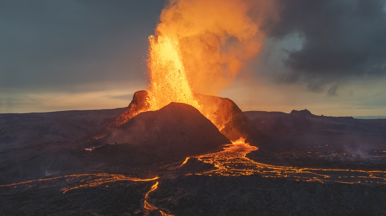
According to GNS Science, in discovering what caused Zealandia to break off from the conjoined edge of Australia and Antarctica, researchers found their smoking gun in the form of a spine-like stretch of volcanoes across Zealandia's 250 to 100-million-year-old "granite backbone." Nick Mortimer, the lead author of GNS Science's study said from 120 to 80 million years ago magma-spewing fissures "stretched and thinned [Zealandia] like pizza dough" even as Zealandia fractured from its bigger siblings. Further research on GeoScienceWorld indicates that Zealandia could even provide geological threads back to a previous supercontinent, Rodinia. This could help clarify the flow of Earth's recurring supercontinent cycle, including its next, projected supercontinent, Amasia.